Watersheds and Watershed Management
We all live in watersheds. Wherever you are, you are in a watershed and your activities influence areas downstream, including Lake Huron.
Visit the CAMaps.ca website to discover the watershed in which you are situated.
A watershed is an area of land that drains to a common waterway, such as a stream, wetland, or lake.
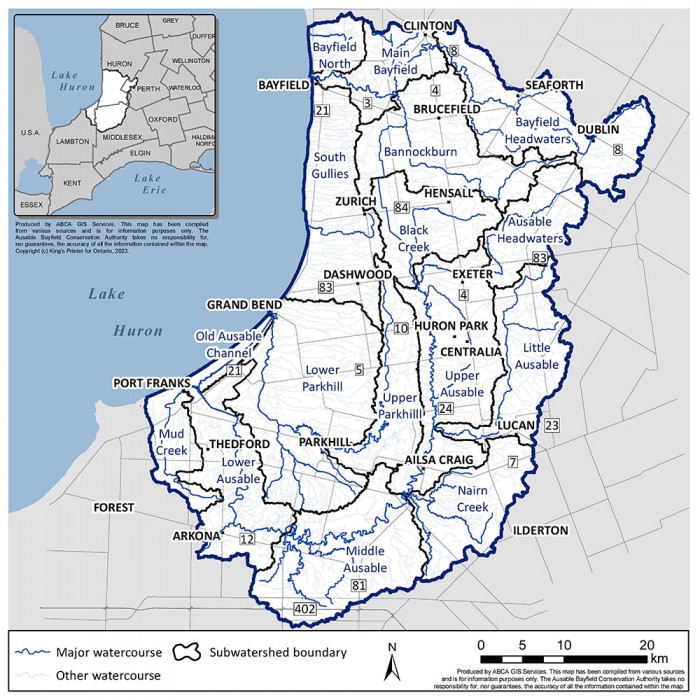
Along the southeast shore of Lake Huron, from Port Franks to north of Bayfield, all land drains into Lake Huron. The water drains to Lake Huron via a river such as the Ausable River, Parkhill Creek, or Bayfield River or through a shoreline tributary.
The 2,440-square-kilometre ABCA area of jurisdiction includes the watersheds of the Ausable River, Bayfield River, Parkhill Creek, Mud Creek and the gullies between Tower Line in Central Huron and Grand Bend which drain directly to Lake Huron.
The physical boundaries of watersheds seldom coincide with political boundaries. Conservation authorities rely on a multi-disciplinary, integrated watershed management approach to manage human activities and natural resources, on a watershed basis, by considering the connected interests and needs of the environment, economy and society.
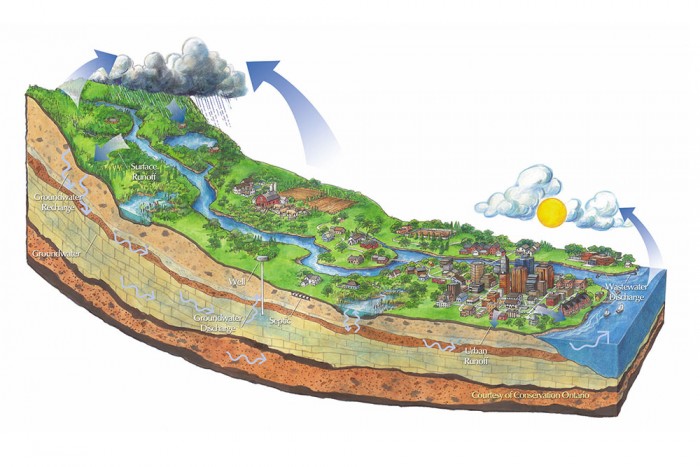
Environmental issues, at the field or homeowner scale, are barely measurable and would typically not be considered a problem. They cumulate to be watershed issues: flooding, erosion, degraded rivers and lakes, and loss of fish and wildlife.
Watercourses and the areas that drain into them, do not start and stop at a municipal boundary. Upstream land use activities can impact downstream communities. In the 1940s, the local municipalities understood this challenge and worked together to form the conservation authority to use the natural-world boundaries of a watershed as a way to manage the local environment to provide benefit to all in the area. Through conservation authorities, local municipalities manage human activities and natural resources with education, planning policies, monitoring, and stewardship.
Conservation authorities rely on a multi-disciplinary approach with perspectives of engineers, agronomists, planners, and ecologists to manage human activities and natural resources. We manage and monitor nature and the working landscape on a watershed basis, to have a more integrated approach rather than managing flooding, erosion, water quality and habitat loss as separate activities.
Integrated Watershed Management
Integrated watershed management recognizes the interrelationships between land management, mitigating natural hazards, and protecting water resources. This approach is recognized internationally as the best model for managing natural resources.
Watershed-Based Resource Management Strategy (WBRMS)
For information on the Watershed-Based Resource Management Strategy visit the Governing Documents web page.
Watershed Management Strategy
Prior to the Watershed-Based Resource Management Strategy (WBRMS), the Watershed Management Strategy 2015-2025 (WMS) was developed to provide direction for the Ausable Bayfield Conservation Authority (ABCA) Board of Directors and staff to implement The Path Forward: Your Community Conservation Strategy for Ausable Bayfield Watersheds (2012). The WMS helps ensure Ausable Bayfield Conservation has a clear direction and understanding of what we need to do to conserve the watersheds.
For maximum flexibility, specific actions are left to staff expertise in the context of specific situations and detailed information. Although intended mainly for ABCA staff and board members, the WMS provides valuable information and strategies to partners.
The WMS included the following goals for the ABCA:
- To preserve, protect, enhance and restore the ecological function of the Ausable Bayfield watersheds;
- To contribute to community health, safety and sustainability;
- To build partnerships, awareness, and engagement at all levels.
Download the Watershed Management Strategy now:
- Watershed Management Strategy 2015-2025 (PDF file)
As part of the Conservation Authorities Act update, ABCA developed the Watershed-Based Resource Management Strategy (WBRMS).
Watershed Report Cards
Ausable Bayfield Conservation Authority prepares Watershed Report Cards every five years as a summary of the state of local forests and water resources. Report cards give residents information to protect and enhance watershed resources.
Conservation Ontario developed standards for report cards for consistent reporting across Ontario.
Report cards are based on forest, surface water quality, and groundwater quality conditions in 16 subwatersheds in the Ausable Bayfield Conservation Authority (ABCA) area: three Bayfield River subwatersheds; eight Ausable River subwatersheds; two Parkhill Creek subwatersheds; Mud Creek; and two smaller Lake Huron subwatersheds.
Watershed Report Cards tell you about your watershed – where more work is needed and where work has been achieving positive results. They also provide ideas for actions you, your community, and local agencies can do to help protect and improve watershed health.
They offer 'Thumbs Up' congratulations to watershed community partners creating awareness and taking positive action as well as the 'Top Action' needed in each of 16 local subwatersheds.
Visit our Watershed Report Cards web page.