Presenters recount impacts of major flood event
Presenters recount impacts of major storm
Ausable Bayfield Conservation Authority hosted annual Flood Emergency Planning Meeting; Community Emergency Management Coordinators among 30 people in attendance for presentation, by ERCA engineers, on 2023 storm event
Ausable Bayfield Conservation Authority (ABCA) hosted its annual Flood Emergency Planning Meeting at the Exeter Legion on February 24, 2025. Guest speakers, from Essex Region Conservation Authority (ERCA), were James Bryant, P.Eng., Director of Watershed Management Services and Lina Florian, P.Eng., ERCA Watershed Engineer.
They spoke about an Essex Region flood event that hit on August 23-25, 2023.
An external source originally classified the approaching rainstorm as ‘moderate,’ but based on existing wet ground conditions in the Essex Region watershed, combined with predicted rainfall amounts, ERCA issued a Flood Watch to alert municipalities. “We took a proactive approach and issued a Flood Watch for our region,” Bryant said. The conservation authority later elevated the Flood Watch to a Flood Warning.
Significant moisture, pushing easterly, and originating from Hurricane Hilary, fueled the storm. “Hurricane Hilary was on the west coast of the U. S. and was tracking all the way (to Canada), hitting parts of Ontario and parts of Quebec,” Bryant said. “Before the significant rainfall hit, we had a pre-wetting of 25-35 millimetres (mm) the day before so we had some wet, saturated ground conditions in our area,” he said. “It only takes about 30 millimetres of rain for our area to get pretty wet and saturated.”
The watershed is generally very flat terrain, he said. There is also a high percentage of clay soils there. That provides less infiltration of water into the ground and leads to more stormwater runoff.
Over a 37-hour period, there was significant rainfall in the ERCA watershed, ranging from about four inches (100 mm) to more than eight inches (200 mm). The southern parts of Essex County were hit hardest by flooding, especially in the towns of Essex and Kingsville and the Township of Pelee (including Pelee Island).
The guest speakers showed photos from the storm event. Roadways looked like rivers in some cases. Water running off of land during the storm washed out roads (leading to road closures), blew out shoreline walls, created pavement instability, and damaged some farms, cottages and homes. Bryant said there were eroded properties, damaged structures, and “ … some pretty significant impacts, especially for these landowners.”
Some people were confined to their homes as roads were covered with water. There was risk to the public and there were negative financial impacts. The storm caused so much damage some houses needed to be torn down.
The effects of the rainstorm also had impacts on municipalities with damage to public infrastructure. There were sewer backups and the rainstorm affected some municipal wastewater treatment plants and sewage lagoons. In one case, flow was 14 times the daily average flow, resulting in raw sewage bypasses.
Conservation authority staff monitored before and during the storm and looked at rainfall Intensity, Duration, and Frequency (IDF) curves. They looked at field observations, of conditions, at a number of climate stations. They used data, from multiple sources, and modeling tools to delineate the approximate extent of flooding. ERCA applies regulations policies based on a one-in-100-year storm event. Looking at a slide on rainfall IDF curves for the storm, Florian said “ ... what’s most notable here is that the Harrow gauge had 80 millimetres (of rain) above the 100-year event (level).” (Harrow also had a major flood event in 1989).
The extensive flooding in August 2023 was test of preparedness for both the conservation authority and municipalities. Following the storm event, ERCA took actions to improve readiness for future events. These actions have included flood kits; budgeting for increased engineering and field support required during and after a flooding event; and increased training for conservation authority and municipal staff.
More than 30 people attended the Flood Emergency Planning Meeting. They included Fire Chiefs, local public health, county and municipal representatives and Community Emergency Management Coordinators.
Also presenting at the meeting were Christie Brown, ABCA Water Resources Technologist, and Davin Heinbuck, ABCA General Manager and Secretary-Treasurer. They provided a winter-spring update on watershed conditions, with a low-moderate risk of flooding, and a presentation of flood emergency roles and responsibilities.
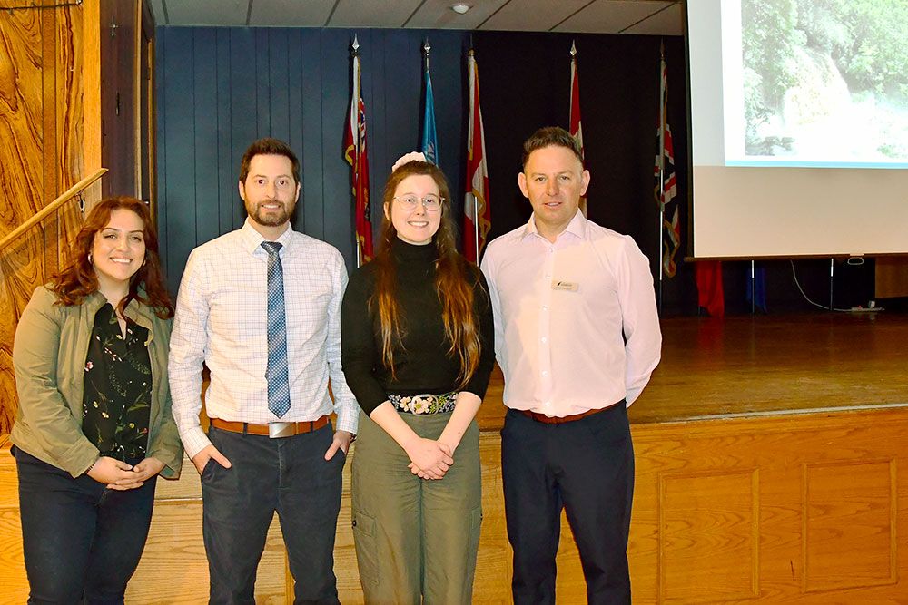
PHOTO: PRESENTERS SPEAK ABOUT FLOOD FORECASTING AND WARNING – Presenting at the Ausable Bayfield Conservation Authority (ABCA) Annual Flood Emergency Planning Meeting in Exeter on February 24, 2025, were (from left to right in photo): Lina Florian, P.Eng., Watershed Engineer at Essex Region Conservation Authority (ERCA); James Bryant, P.Eng., ERCA Director of Watershed Management Services; Christie Brown, ABCA Water Resources Technologist; and Davin Heinbuck, ABCA General Manager and Secretary-Treasurer. The ERCA engineers spoke about the impacts of a storm event that hit Essex County in August of 2023. The ABCA staff spoke about the Flood Emergency Plan and roles and responsibilities during flooding events, and about current watershed conditions and flood risk. More than 30 people, including Community Emergency Management Coordinators, attended the meeting.
ABCA staff present about flood risk, Flood Emergency Plan, and roles and responsibilities during flood events
Ausable Bayfield Conservation Authority (ABCA) staff were among the presenters at the annual Flood Emergency Planning Meeting held at the Legion Hall in Exeter on Monday, February 24, 2025.
Davin Heinbuck, ABCA General Manager and Secretary-Treasurer, spoke about how the conservation authority protects life and property through programs that manage natural hazards such as flooding and erosion and through flood forecasting and warning for municipalities. He spoke about roles and responsibilities of the Province of Ontario; municipalities; conservation authorities; and other agencies during flood events. He also spoke about the Flood Emergency Plan.
He said, through programs such as regulations and permitting and plan review, the conservation authority helps to “ ... keep people out of harm’s way from hazards of flooding and erosion.” Some older development, however, had taken place in hazard areas before planning and regulations programs were in place to manage development. Emergency planning and response is required, especially in those areas prone to flooding.
“This meeting is an example of how we do that and why we do that ... working with municipal partners to plan for flooding emergencies,” he said. “If we’re into a flooding event, we have a flood forecasting and warning program, that delivers messaging, we monitor, and we advise municipalities and our other partners of flood potential and flood risk.” ABCA monitors streamflow conditions and weather forecasts; maintains data networks; provides messaging and response during an event and liaises with municipalities. That communication with municipalities takes place during a flood event and after an event.
In addition to monitoring ice in watercourses, ABCA staff collect data in the field with ‘boots on the ground’ and ‘eyes on the ground’ through river watch monitoring and by measuring, in the field, the extent of the snowpack and the snow water equivalent. They also monitor real-time weather conditions and incorporate weather forecasting into their models. The combination of all these data streams, along with the operation and calibration of ABCA’s flood modeling, allows the conservation authority to provide important and timely information to municipalities, especially those that may be downstream, leading up to and during a flood event.
Other ways the conservation authority helps to protect life and property is through flood control structures and infrastructure along watercourses to divert floodwaters away from towns. ABCA monitors and maintains these structures as part of the flood plain management program.
The ABCA General Manager gave attendees a message that while flooding may be infrequent, it does happen and, in some cases, it is unpredictable. He spoke about the difference between a Flood Watch (where there are the ingredients present for a flood to take place) and a Flood Warning (when the flood is occurring or imminent). He shared photos of several local flooding events that have happened in recent years. He also spoke about the different river systems in the ABCA area, including the Ausable River; Bayfield River; Parkhill Creek; Mud Creek; and Gullies watersheds.
Christie Brown, ABCA Water Resources Technologist, provided the meeting with a winter-spring update on watershed conditions and assessing the risk of flooding. At the time of the meeting, there was a mix of frozen areas and wet, unfrozen sections of the watershed. There was quite a bit of river ice, she said, in some cases a foot or more of ice depth. ABCA staff record the depth of snow and also how much water equivalent there is in that snow. This data, along with other weather-related data, informs model predictions of the extent of potential flooding.
The risk of riverine flooding in the watershed was rated low to moderate at the time of the meeting. This is based, in part, on weather forecasts suggesting temperatures high enough to lead to melting of snow but not so high that the melting will take place rapidly. There is also the prospect that water can infiltrate into the unfrozen ground so the amount of water running off of land is moderated. The actual level of flooding will be affected if rising temperatures exceed forecasts. The risk of ice jams and lake flooding were rated as low risk at the time of the meeting. This is affected, in part, by relatively low lake levels (although it is expected lake levels will rise from current levels).
The flood emergency planning meeting was held at the Royal Canadian Legion Hall, RE Pooley Branch 167, on William Street, Exeter. This was the second year ABCA hosted this meeting at that location. Ray Chartrand, Chair of the ABCA Board of Directors, welcomed the attendees to the Flood Emergency Planning Meeting.
More than 30 people attended the meeting including Community Emergency Management Coordinators (CEMCs), municipal elected representatives, local public health, Fire Chiefs, conservation authority staff, and county and municipal staff.
To learn more visit the Ausable Bayfield Conservation website at abca.ca and the flood messages web page.