Morrison Dam Conservation Area
Notice of Consultation Opportunity for Public to Provide Input into Draft Master Plan for Morrison Dam Conservation Area
Date of Notice: July 16, 2026
Ausable Bayfield Conservation Authority invites the public to provide input, through written comments, that will inform the draft Master Plan 2026-2036 for Morrison Dam Conservation Area (MDCA).
We welcome your input, through this survey, until Monday, August 24, 2026.
- Draft Master Plan for Morrison Dam Conservation Area 2026-2036 – 1 MB (medium-sized) PDF file
- To provide your written comments and input into the draft master plan, take the Survey on Draft Master Plan for Morrison Dam Conservation Area 2026-2036 now.
This survey is to provide the public with the opportunity to provide input, through written comments, that will inform the draft Master Plan 2026-2036 for Morrison Dam Conservation Area.
Thank you for your participation in this survey on the draft Master Plan 2026-2036 for Morrison Dam Conservation Area.
We value your feedback. Your input will help to shape the best possible plan for the future.
Some of the questions refer directly to the draft document.
To review the draft document, please visit our Public Consultation web page.
About Morrison Dam Conservation Area
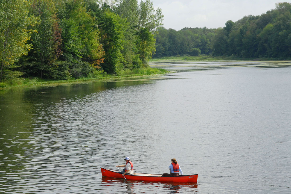
Morrison Reservoir (Morrison Lake) is a human-made reservoir created by the construction of Morrison Dam in 1959 to provide a consistent water supply to a former canning factory in the town of Exeter.
Today, the area offers a unique ecosystem with many recreational opportunities. We invite you to explore Morrison Dam Conservation Area (MDCA) throughout the year and experience all its natural wonders!
Open seven days a week, from sunrise to sunset, unless otherwise posted.
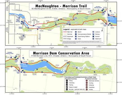
Download the trail map and booklet now:
- Brochure and trail map MDCA – PDF file.
- South Huron Trail brochure and trail map – PDF file
Where is Morrison Dam Conservation Area (MDCA)?
Address: 71108 Morrison Line, RR 3, Exeter, Ontario, Canada, N0M 1S5
Morrison Dam Conservation Area is located 2 km east of Exeter, on Morrison Line, south of Highway 83.
You may also find this Google Map link helpful:
Recreational Trails
Explore Morrison Dam Conservation Area’s four-kilometre (2.5 mile) of recreational trail and travel along two kilometres (1.2 miles) of wide, accessible trails with an optional excursion down an additional two kilometres (1.2 miles) of more rugged trails.
CAUTION: These are nature trails. Trail surfaces and boardwalks may be slippery or uneven. Be especially careful during windy, wet and icy conditions.
- Use caution and avoid trails if covered in water
- Wear appropriate clothing, footwear and equipment for your preferred trail activity.
- Stay away from fast-flowing water.
Cycling
Cycling is allowed along the main trail only.
Trail etiquette
Share the trail. Keep on the right, pass on left.
Be a safe cyclist. Cycle slowly, give right-of-way to hikers, use a bicycle bell to warn hikers, be cautious at curves, and wear a helmet.
Picnicking
Morrison Dam Conservation Area is a great place for a picnic or family reunion. The pavilion is available on a first-come, first-served basis. If you wish to reserve the pavilion, please contact the ABCA for fees and details.
Fishing
Fishing is permitted in compliance with applicable legislation. Outdoor Cards and Fishing Licences can be purchased from Service Ontario and other licence issuers. Please release any fish caught out of season.
There is a number of native fish species in the Ausable River and in Morrison Reservoir (Morrison Lake).
Geocaching
Geocaching is a worldwide game of hide and seek that uses GPS (Global Positioning System) technology to help people find hidden treasures called ‘caches.’ There are two geocaches at the Morrison Dam Conservation Area east of Morrison Line (more caches can be found west of Morrison Line, along the MacNaughton-Morrison Section of the South Huron Trail).
Caches are of different sized waterproof containers and are hidden in a safe spot close to trails. They often contain a logbook and simple treasures like coins or toys inside. If you find a camouflaged cache by accident, have a look and put it back in the place you found it for others to enjoy.
Visit geocaching.com to find and download coordinates and clues to find these ‘treasures’ at the Morrison Dam Conservation Area.
Interested in setting up a new geocache at an ABCA property? Check out this fact sheet for guidelines on how to do it:
- Geocaching Web Page
- Geocaching Fact Sheet - PDF file
Commemorative Woods
Located on the north side of the trail the Commemorative Woods is a place for family and friends to plant trees as a living memorial and legacy. Trees can also commemorate special occasions where a long-lasting natural tribute is appropriate.
Visit the Commemorative Woods web page link to find out more on how to plant a commemorative tree.
Rules and Regulations
Rules
Rules protect the environment, you and your fellow users. These rules must be followed and are be enforced under the Conservation Authorities Act and Trespass to Property Act.
Please refer to signs and entrance kiosks for permitted and prohibited activities.
- The property is closed to the public between sunset and sunrise.
- Motorized vehicles, motor boats, e-bikes, horses, hunting, drones, alcohol use and camping are not permitted.
- Campfires are permitted only in the one fire pit in the open area near the fishing docks at Morrison Dam.
- Dogs must be on a leash, under control, and you must clean up after your dog.
- Ensure your pet does not damage or interfere with vegetation or wildlife and does not interfere with others’ enjoyment.
- Do not remove or damage plants, trees, wildlife, signs or structures.
- Stay on the trails and respect neighbouring landowners.
- Fishing is permitted in compliance with applicable legislation.
- Don’t litter.
Please report vandalism and incidents to the Ausable Bayfield Conservation Authority (ABCA) at 519-235-2610 or toll-free 1-888-286-2610.
For a list of permitted activities, please visit the ‘Permitted Uses’ web page at this link:
Watch the videos now:
- Morrison Dam Conservation Area Section of the South Huron Trail Video
- MacNaughton-Morrison Section of the South Huron Trail Video
Morrison Dam Reservoir has provided recreation, nature enjoyment, habitat benefits for more than 60 years
Morrison Dam Reservoir is one of area’s only inland lakes
More than sixty years ago (in 1958), local partners created Morrison Dam and Morrison Dam Reservoir (Morrison Lake) east of Exeter.
The dam and reservoir were created, in part, to supply water for the former canning factory in Exeter. At that time, the business was a major employer and purchaser of local crops and the canning factory needed a reliable supply of water to cool the cans.
The former Ausable River Conservation Authority built the dam “with the financial assistance of both the Town of Exeter, which also gained a supplementary water supply, and the Township of Usborne, because situating the dam on the road allowance upstream from Exeter meant the replacement of an obsolete Township bridge,” according to engineer Charlie Corbett in his article From an Engineer’s View in the booklet 40 Years of Conservation.
The conservation authority began work to build the dam and reservoir in the mid-1950s and completed the work in 1958. The dam and reservoir are named after John A. Morrison.
Today, Morrison Reservoir is one of the only inland lakes in the area. The lake isn’t used as a water supply anymore but it offers many important benefits such as habitat for aquatic and terrestrial species and recreation for residents and visitors. The water surface area of the lake, at the normal summer level, is about 25 acres. At the normal summer level, the maximum reservoir depth is about 16 feet with the average depth around six feet.
People enjoy canoeing, kayaking, fishing, and nature appreciation on Morrison Lake.
Andrew Dixon, in the booklet A Tour through 25 Years of Conservation (1971), wrote that if you like to fish, canoe, or watch birds, “then the Morrison Lake is for you and is a beauty spot worth a visit.”
The conservation authority planted trees around Morrison Lake to create wildlife habitat and Morrison Dam Conservation Area (MDCA) was born.
People enjoy walking, hiking, and other multi-use trail uses such as bicycling at the conservation area. The conservation area is also home to the administration centre and office of Ausable Bayfield Conservation Authority (ABCA). The conservation area surrounding the Reservoir maintains areas of wetland habitat for many species of plants and animals.
The trails of the conservation area join with MacNaughton-Morrison Trail to form the eight-kilometre South Huron Trail.
Today, it is hard to imagine the local landscape without Morrison Dam, Morrison Lake, and the surrounding protected conservation area. David McClure, in his 2006 Annual Report article about conservation authority history between 1956 and 1960, wrote that the creation of Morrison Dam was one of the late-1950s projects that turned vision into action. He wrote that “the environmental benefits and recreational enjoyment,” of two major projects including Morrison Dam, “are the living legacy that grew out of the roots of that vision by local conservation pioneers.”
Jones Bridge - A new pedestrian bridge constructed on South Huron Trail
A community campaign took place to raise funds to create a pedestrian bridge, downstream of Morrison Dam, to join two sections of the South Huron Trail. This bridge, called Jones Bridge, provides trail users with a safer, more scenic alternative to walking beside vehicle traffic on the roadway in order to enjoy both trail sections.
The community raised more than $300,000 towards the trail bridge project, surpassing the campaign fundraising goal, and turned the Jones Bridge dream into reality in 2018.
The bridge is called Jones Bridge as it is dedicated by Donna Jones, in loving memory of Ted Jones, who was a dedicated community volunteer, conservationist, Exeter Lions Club member and Ausable Bayfield Conservation Foundation director.
The Brian Clarke memorial stairs have been constructed thanks to a generous donation, in Brian's memory, by his family.
To find out more about Jones Bridge visit this link: